Case Studies
Global Forest Cover Change
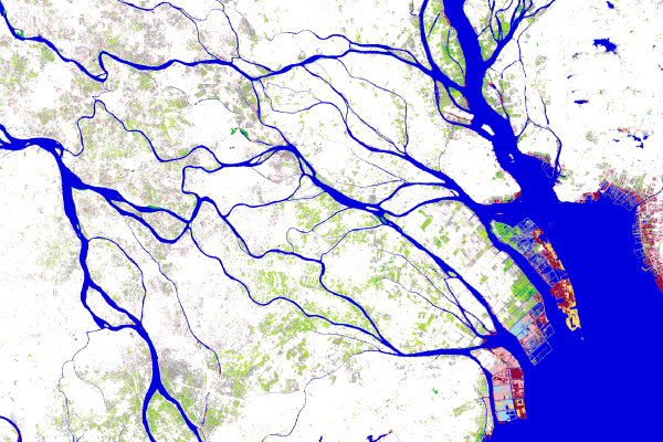
A team led by University of Maryland’s Matt Hansen used Earth Engine to survey over a decade of global tree cover extent, loss, and gain. The study, published in Science, analyzed nearly all global land, excluding only Antarctica and some Arctic islands. This area comprises 128.8 million km2, which is the equivalent of 143 billion pixels of Landsat data at a thirty-meter spatial resolution. To conduct such extensive analysis, Earth Engine performed computations in parallel across thousands of machines, as well as automatically managed data format conversion, reprojection and resampling, and image-to-pixel metadata association. Learn more.
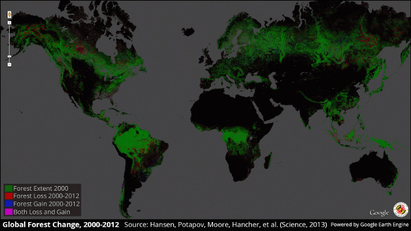
This is the first map of forest change that is globally consistent and locally relevant. What would have taken a single computer 15 years to perform was completed in a matter of days using Google Earth Engine computing.
Map of Life
The Map of Life team has developed an interactive map for conservators to view and analyze habitat ranges and to assess the security of individual species. Using Earth Engine to combine data from a variety of sources, Map of Life has refined their predictions for pinpointing the locations of at-risk species. Users can adjust the parameters (indicating, for instance, a species' preferred habitat), and Earth Engine updates the map on-the-fly, immediately showing the impact on the species range and the amount of protected habitat. Learn more.
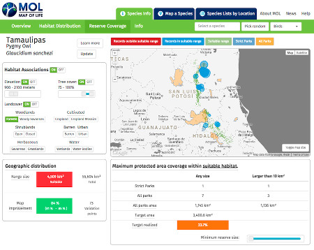
Earth Engine's scalable and cloud-based technology helps us deliver vastly improved estimates about the status and trends of tens of thousands of species to users in science, conservation and policy anywhere in a visual and interactive way.
Global Forest Watch
Global Forest Watch, an initiative of the World Resources Institute, is a dynamic online forest monitoring system designed to enable better management and conservation. Global Forest Watch uses Earth Engine to measure and visualize changes to the world's forests; users can synthesize data from over the past decade or receive alerts about possible new threats in near-real-time. Launched in 2014, it’s now used by corporations, non-profits, governments, and indigenous groups for applications as diverse as protecting against illegal logging and ensuring supply chain transparency. Learn more.
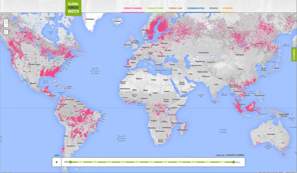
Google Earth Engine has made it possible for the first time in history to rapidly and accurately process vast amounts of satellite imagery, identifying where and when tree cover change has occurred at high resolution. Global Forest Watch would not exist without it. For those who care about the future of the planet Google Earth Engine is a great blessing!
Tiger Habitat Monitoring
A team led by University of Minnesota's Anup Joshi developed a satellite-based monitoring system to track changes and prevent loss to critical endangered wild tiger habitats. Using Google Earth Engine, forest loss data generated by Dr. Matt Hansen and Google, and other data available at Global Forest Watch, the team assessed the changes to all critical tiger habitats over a 14 year period. The assessment is the first to track all 76 areas prioritized for wild tiger conservation across 13 different countries. Their analysis found that the international goal to double the wild tiger population by 2022 is achievable with effective forest protection and management. Learn more.
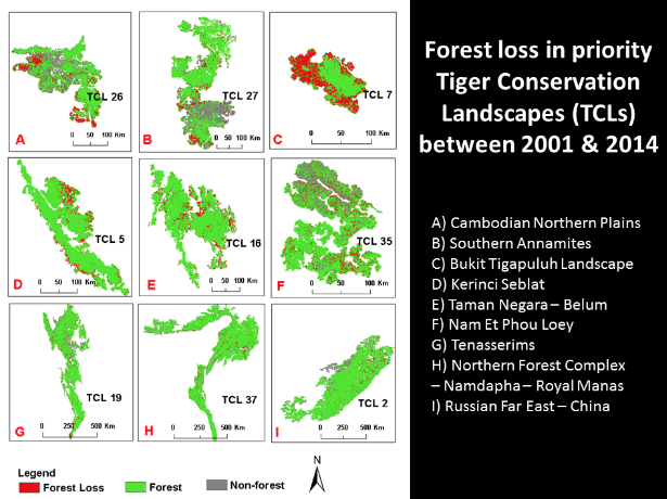
It took us about 1.5 years each to do the previous two range-wide tiger habitat analyses, but with Google Earth Engine we were able to get it done in less than a week.
Malaria Risk Mapping
Scientists in the Global Health Group at the University of California, San Francisco, are using Earth Engine to predict malaria outbreaks. When their tool is released, local health workers will be able to upload their own information about known cases of malaria, and the platform will combine it with real-time satellite data to predict where new cases are likely to occur. Learn more.
Here at the UCSF Global Health Group, we have been using Earth Engine as the workhorse for an online Disease Surveillance And Risk Mapping (DiSARM) platform for malaria. Earth Engine makes accessing, processing and analyzing remotely sensed data so much easier than other more manual methods and, as it is updated frequently, allows us to automate malaria risk mapping in near real time.
Collect Earth
Collect Earth, developed by the Food and Agriculture Organization (FAO) of the United Nations, is a free, open source, and user-friendly tool using Google Earth and Google Earth Engine to visualize and analyze plots of land in order to assess deforestation and other forms of land-use-change. Launched in 2014, Collect Earth is part of the Open Foris software suite, designed to help government, universities and non-profit organizations monitor land use, desertification, forest change, and land-use dynamics. Learn more.
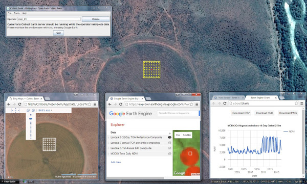
Collect Earth is a game changer – thanks to Google Earth Engine, we will be able to monitor the world’s forests much more efficiently together with all other actors.
Global Surface Water
The European Commission's Joint Research Centre (JRC) has used Earth Engine to develop high-resolution maps of global surface water occurrence, change, seasonality, recurrence, and transitions. The study, published in Nature, analyses Landsat images collected over the past three decades to identify both permanent and seasonal water bodies. Understanding these changes is vital for ensuring the security of our global water supply for agriculture, industry, and human consumption; for assessing water-related disaster reduction and recovery; and for the study of waterborne pollution and the spread of disease. Learn more.